Kavar County
Kavar County
Persian: شهرستان کوار | |
|---|---|
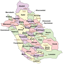
 Location of Kavar County in Fars province (center left, green) | |
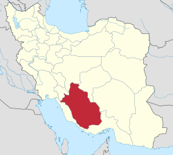
 Location of Fars province in Iran | |
| Coordinates: 29°15′N 52°43′E / 29.250°N 52.717°E[1] | |
| Country | |
| Province | Fars |
| Capital | Kavar |
| Districts | Central, Tasuj |
| Population (2016)[2] | |
| • Total | 83,883 |
| Time zone | UTC+3:30 |
Kavar County (Persian: شهرستان کوار) is in Fars province, Iran. Its capital is the city of Kavar.[3]
History
[edit]In 2010, Kavar District was separated from Shiraz County in the establishment of Kavar County, which was divided into two districts of two rural districts each, with Kavar as its capital and only city at the time.[3]
After the 2016 National Census, the villages of Akbarabad,[4] Mozaffari,[4] and Tasuj[5] were elevated to city status.
Demographics
[edit]Population
[edit]At the time of the 2011 census, the county's population was 77,836 people in 19,681 households.[6] The 2016 census measured the population of the county as 83,883 in 23,013 households.[2]
Administrative divisions
[edit]Kavar County's population history and administrative structure over two consecutive censuses are shown in the following table.
| Administrative Divisions | 2011[6] | 2016[2] |
|---|---|---|
| Central District | 55,633 | 60,714 |
| Farmeshkan RD | 6,220 | 5,883 |
| Kavar RD | 23,071 | 23,120 |
| Akbarabad (city)[a] | ||
| Kavar (city) | 26,342 | 31,711 |
| Mozaffari (city)[a] | ||
| Tasuj District | 21,902 | 23,159 |
| Fathabad RD | 10,843 | 11,960 |
| Tasuj RD | 11,059 | 11,199 |
| Tasuj (city)[b] | ||
| Total | 77,836 | 83,883 |
| RD = Rural District | ||
See also
[edit]![]() Media related to Kavar County at Wikimedia Commons
Media related to Kavar County at Wikimedia Commons
Notes
[edit]References
[edit]- ^ OpenStreetMap contributors (4 October 2024). "Kavar County" (Map). OpenStreetMap (in Persian). Retrieved 4 October 2024.
- ^ a b c Census of the Islamic Republic of Iran, 1395 (2016): Fars Province. amar.org.ir (Report) (in Persian). The Statistical Center of Iran. Archived from the original (Excel) on 6 April 2022. Retrieved 19 December 2022.
- ^ a b Rahimi, Mohammadreza (22 November 2010). "Four changes in the map of country divisions: Kavar County is formed in Fars province". dolat.ir (in Persian). Ministry of the Interior, Board of Ministers. Archived from the original on 15 March 2017. Retrieved 20 November 2023 – via Secretariat of the Government Information Council.
- ^ a b c Jahangiri, Ishaq (c. 2023) [Approved 4 February 1400]. Letter of approval regarding national divisions in the Central District of Kavar County, Fars province. qavanin.ir (Report) (in Persian). Ministry of the Interior, Council of Ministers. Subject Letter 184291. Archived from the original on 20 September 2023. Retrieved 20 September 2023 – via Laws and Regulations Portal of the Islamic Republic of Iran.
- ^ a b Fazli, Abdolreza Rahmani (21 September 2017) [Approved 13 September 1396]. "Notification of the resolution of the Ministry of the Interior regarding the transformation of Tasuj village, the center of Tasuj District in Kavar County in Fars province, into a city". dotic.ir (in Persian). Ministry of the Interior. Letter 148509. Archived from the original on 1 July 2021. Retrieved 20 September 2023 – via Laws and Regulations Portal of Iran.
- ^ a b Census of the Islamic Republic of Iran, 1390 (2011): Fars Province. irandataportal.syr.edu (Report) (in Persian). The Statistical Center of Iran. Archived from the original (Excel) on 16 January 2023. Retrieved 19 December 2022 – via Iran Data Portal, Syracuse University.

